------
Louisville's National Day of Civic Hacking event wrapped up this past Saturday May 31. How did it go?
Success!
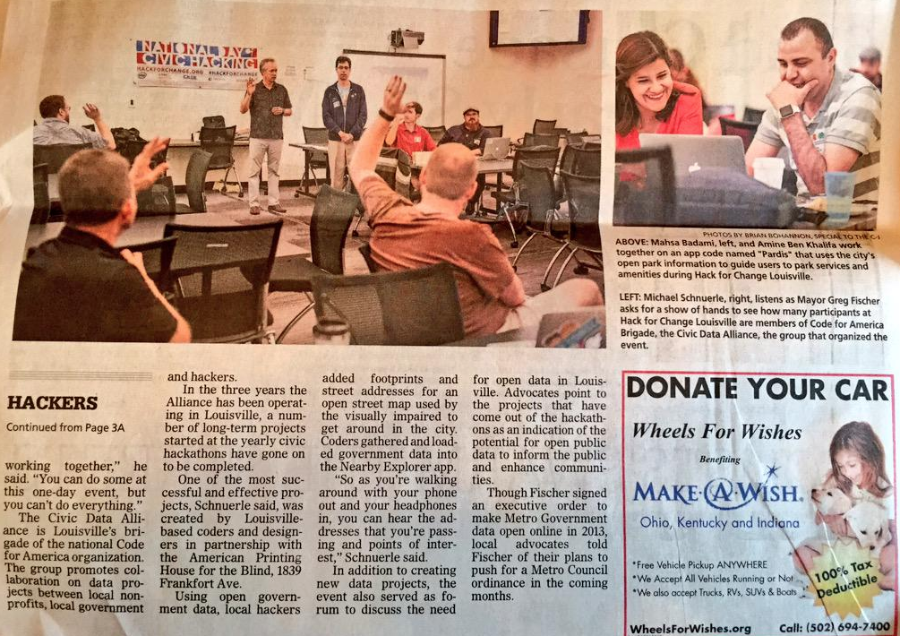
The event was a huge success! The organizers, Louisville's
Civic Data Alliance, would like to thank everyone who participated including Greg Fischer (Louisville Metro’s Mayor), Ted Smith (City Innovation Director), and Tim Welsh (Metro CIO).
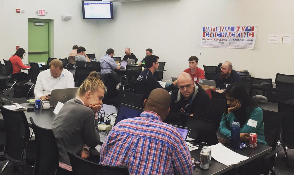
We had 45+ people sign up and attend. We were part of over 100 cities, 124 events, and 10,000 participants across the nation.
Civic Data Alliance

The Civic Data Alliance is Louisville’s official Code for America brigade, and the organizing body for this year’s NDoCH. If you want to join us, discover projects we are working on, and join our monthly meetups, please
visit our site and sign up on our forums.
The Projects
We focused on 5 projects to build and ship in just 6 hours, based on data available and interest levels. Here's a summary of each of them.
1. WFPL Curious City
We deployed the first version of WBEZ's Curious City Project, for WFPL in Louisville.
"What do you wonder about Louisville, the region or its people that you want WFPL to investigate?"
2. NC3 Neighborhood Editor
The
Network Center for Community Change needed a way for locals to improve the accuracy of locations and mapping in the neighborhoods their volunteers and community members know. So we built a neighborhood explorer with links to editing features easily in Open Street Map.
"NC3 believes that community-generated data created by neighborhood residents and advocates is a powerful tool for change. With this data we are making change together, and we need you to join the movement!
NC3 has developed this web site to help introduce people to the geography of West Louisville neighborhoods, while offering an avenue to add and share data on OpenStreetMap. OpenStreetMap is a collaborative project to create a free editable map of the world, and it’s the perfect tool to create data for West Louisville Neighborhoods that can be updated and shared by everyone. So take a look at the neighborhoods on this site and start editing!"
3. NC3 Shareabouts
NC3 also needed a way for locals to share positive locations and memories in their neighborhoods. So we worked with them to deploy a
Shareaboutsplatform.
4. Shelter Helper - Adopt a Pet
Using the city's open data portal and Metro Animal Services pet data, we built a website where you can serach, filter, and browse the available animals to adopt, and then get driving directions texted to your phone to go pick up your sweet little pet.
5. Louisville Minecraft
Our most ambitious project for the day was to recreate Louisville within Minecraft, just like Denmark did! It was the only project that didn't ship (though we got it working after the event around 6pm because people stayed to help). But we got a good handle on the process and with the right data we know it can be done!
It did take us 2 hours to download/merge/clip less accurate data from Kentucky's open GIS portal, since that data was not available on the city's open data portal (which would have taken a few minutes instead).
Links we used:
Roadblocks
Our biggest roadblock, which directly affected the success of 3 of the 5 projects, was the lack of open GIS and mapping data from the city of Louisville. We had to work harder to turn to alternative, less accurate sources, and in some cases pay another company out-of-pocket for data we needed.
More Event Pictures
Info from 2014 Event Page
HACK FOR CHANGE
Hack for Change Louisville is being held as the city's formal
National Day of Civic Hacking event, one of over 119 simultaneous events across the United States. The day will bring together local government leaders and staff, local organizations, businesses, visitors, and community members and is focused on civic innovation. Here's what to expect:
- Software development (a hackathon event) using open public data.
- Collaborative building of open data apps and services for non-profits and the community.
- Discussions on open data at the city, county, and state levels.
- Networking, learning, fun, and making a difference!
The initiative is a united national effort to connect citizens and government in a partnership focused on improving people’s daily lives through technology. This event will bring together techies, entrepreneurs, do-gooders, activists and others like you from across the nation to collaboratively create, build, and invent tools using publicly-released data.
Civic hacking as a form of citizen engagement and volunteerism is gaining momentum reaching cities across America not those known for technology and innovation. Civic hackers are already active and contributing to the betterment of your community.
THE STORY
Hack for Change Louisville has these main goals:
- Create a one-day environment for entrepreneurs, app developers, and programmers to create innovative apps and websites using open public data.
- Identify opportunities to brainstorm, capture, design, and even deploy valuable software applications that serve the city.
- Bring together local government officials, municipal employees, experts, programmers, designers, citizens and journalists to share thoughts on the City of Louisville's open data portal.
- Foster communities of practice and advocacy on the role of the civic innovation, mobile communication, online information, and open data at the City of Louisville.
- Discover other datasets that contain public information a the city, county, and state level that should be made public (property, transit, GIS, etc).
- Create outcomes that participants will act upon after the event is over.
LOCATION
Nucleus is this year's gracious host and location sponsor. Last year Nucleus hosted the event as well, at their nearby
iHub coworking space.
Enter in the parking lot off Floyd St directly across from iHub. Then walk in these doors.
The space is great and we'll have a projector, mics, speaker system for music, Wi-fi, fridge, food, power strips and more!
SCHEDULE
8am - Doors open, mingling, coffee, breakfast, setup
9am - Introductions and overview, project tracks review
9:30 - Break into self-organized groups to work on projects
12 - Lunch on site
1 - Continue working on ideas, finish prototype
4:30 - Present prototypes and successes
5:00 - Next steps, mailing lists/groups, wrap-up
6 - Civic Hacking end, head off to dinner and drinks with your new friends
PROJECT TRACKS
We are pre-planning a number of projects for this year's event, idenifying resources and laying the groundwork in advance. You can align yourself with one of these projects we hope to ship by the end of the day, or come with your own ideas.
- Help one of our non-profits (list coming soon) get their data online for the public
- Create an open data portal on CDA website (or yours) using CKAN, and fill it with community data
- Use Louisville GIS data to build the city in Minecraft, like Denmark
- Getting data from Louisville's Air Quality Eggs
- Editing Open Street Map in your neighborhood
- Setup Curious City for a local non-profit
- Deploy Shareabouts crowdsourced mapping application for a non-profit
- Map trails and points of interest for Bernheim Forest
- Take raw Olmsted Parks data and visualize new tree plantings in Shelby Park
At this event, we are going to focus on finishing a product in just 7 hours. Just like at
Hacktucky, the motto will be "if it doesn't ship, it doesn't exist!" So we'll work together to make a
MVP and cut features as needed. Idea, design, data, coding, UI, and hosting all needs to come together, so we need everyone's help!
SWAG!
Amazon is providing $50 in free
AWS credit to all attendees again this year!
And we've got some cool wrist bands, stickers, and a few hoodies to hand out.
WHAT TO BRING
Your laptop, power cables, software, smart phones, chargers, monitors, mice, ideas, and half finished projects.
HOW TO PREPARE
Familiarize yourself with at these data sources to see what's out there:
The event is meant to be a technical programming, app building, hacking experience. We will be working together to build actual apps during the event.
If you are non-technical, we still need your help. During the event entrepreneurs business, marketing, and regular citizens can help steer the direction of the development and explore great ideas with the techies, and work on the presentation and communitating the idea clearly. You can also spend some time updating your neighborhood's Open Street Map data using the new
iD online editing tool.
VOLUNTEERS
We are looking for volunteers for this year's event to help with organizing, planning, day-of activities, picking up food and drinks, etc. Contact us at the
Civic Data Alliance, Louisville's Code for America brigade and the organizing body for this year's NDoCH. Sign up and post at the official
Civic Data Alliance forums and look there and
on Twitter for meetup times.
HASHTAGS
RESOURCES
As a national contributor for NDoCH, YourMapper has made its open data and CrimeScore APIs open to all hackers for free!
SPONSORS
Contact us to become a food, in-kind, monetary, or sponsor, and get your logo below and shout outs at the event!
MEDIA COVERAGE
- Insider Louisville - #Hackville returns: National Day of Civic Hacking on Saturday, May 31
- WHAS11 - National Day of Civic Hacking comes to Louisville
CONTACT
Contact one of your local organizers (listed below) to find out how to help, sponsor, or if you have questions. About National Day of Civic HackingOn May 31 and June 1, 2014, we’ll be making history all over again. For the second time, the National Day of Civic Hacking will unite technologists, entrepreneurs, developers and other citizens in using open data to improve communities and the governments that serve them.
SPONSORS & PARTNERS